


Danyang Geopark

Danyang Geopark
Overview of the Danyang Geopark
| 01Area | 781.06 km² |
|---|---|
| 02Designation Date |
- National Geopark : July 27, 2020 - Unesco Global Geopark : April 17, 2025 |
| 03Number of Geosites | 43 |
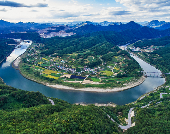
The Danyang region exhibits a well-balanced distribution of sedimentary, metamorphic, and igneous rocks, making it one of Korea's most geologically diverse areas. The extensive limestone zone has developed characteristic karst landforms, including limestone caves, karren, and dolines, while the regions composed of gneiss and granite form part of the highlands of the Baekdudaegan Range, hosting numerous geological and geomorphological heritage sites.
Throughout geological time, the Danyang area has undergone four major tectonic deformation events, resulting in a complex array of structures such as large thrust faults, major fault zones, folds and refolds, three-dimensional fold systems, kink bands, and overturned strata. Because of this structural diversity, Danyang is often referred to as the treasure house of structural geology in Korea. Notably, field exposures reveal fault contacts between Precambrian granite gneiss and Cambrian Jangsan Quartzite, as well as unconformities between strata of different geological ages, allowing direct observation of crustal deformation and the long-term evolution of the Korean Peninsula.
Danyang is also where the Taebaek-type and Yeongwol-type formations of the Joseon Supergroup directly meet along the Gakdong Fault. Although metamorphism and deformation have limited the preservation of fossils, stratigraphic correlation with adjacent regions such as Yeongwol, Taebaek, and Jeongseon remains possible. Because the area contains a continuous sequence of rocks from multiple geologic periods, it provides an ideal natural laboratory for paleomagnetic studies, contributing valuable insights into the geological history and tectonic evolution of the Taebaek Basin.
Geological Characteristics of the Danyang Geopark
| 01Treasure House of Structural Geology |
|
|---|---|
| 02Research Site for Geo-Biosphere Co-evolution |
|
| 03Evidence Site of Earth's Five Major Mass Extinctions |
|
| 04Diverse Karst Landforms |
|
| 05Optimal Site for Global Climate Change Research |
|
| 06Habitat for Unique Cave Fauna |
|
The Treasure House of Structural Geology
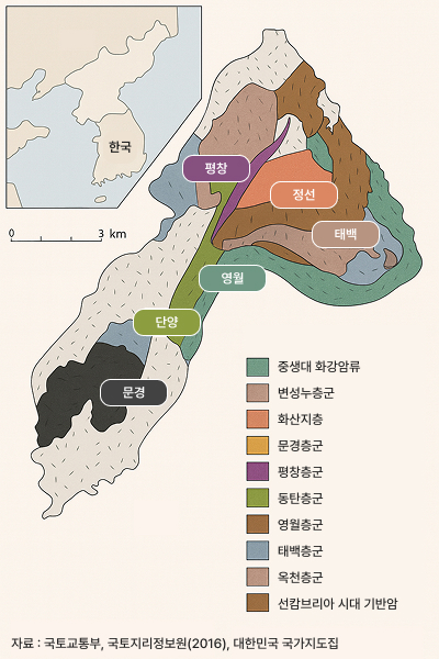
The Danyang region is often described as a natural archive of Korea's geological evolution, encompassing rock formations from the Paleoproterozoic Era (approximately 1.8-1.9 billion years ago) to the Paleozoic, Mesozoic, and Cenozoic Eras. This diversity makes Danyang one of the most geologically varied regions in the Republic of Korea. Within the area, visitors and researchers can observe a full spectrum of lithologies from Paleoproterozoic metamorphic rocks and Paleozoic limestones and sedimentary sequences, to Mesozoic and Cenozoic granitic intrusions. A major fault trending northeast-southwest traverses the Danyang Basin, dividing two key stratigraphic domains: the Yeongwol Group of the Joseon Supergroup to the northwest, and the Taebaek Group to the southeast. This fault contact provides a critical reference point for understanding the structural continuity and stratigraphic correlation of the central Korean Peninsula.
The Danyang area preserves abundant evidence of multiple tectonic deformation events, recording at least four major orogenic phases in the region's geologic history. As a result, a wide variety of structural features can be observed, including: Thrust faults and major fault zones, Unconformities representing gaps in geologic time, Folds, refolds, and complex three-dimensional fold systems, Kink bands and overturned strata. These structures illustrate the dynamic processes of crustal deformation and mountain building, making Danyang one of Korea's most important natural sites for field-based structural geology research. Because of this exceptional geological record, the area is frequently referred to by geologists as the treasure house of structural geology.
Progress Status
| Danyang County's Progress Toward UNESCO Global Geopark Designation | |
|---|---|
| 2020.07. | Designated as Korea's 13th National Geopark |
| 2022.06. | Applied for UNESCO Global Geopark Candidacy |
| 2023.05. | Selected as a National Candidate for UNESCO Global Geopark (Ministry of Environment) |
| 2023.06. | Submitted Letter of Intent to UNESCO |
| 2023.09. | Attended UNESCO Global Geoparks Conference (Morocco) |
| 2023.11. | Submitted Official UNESCO Global Geopark Application |
| 2024.01. | Prepared for UNESCO On-site Evaluation |
| 2024.03. | Established the Danyang Tourism & Geopark Council |
| 2024.03. | Underwent UNESCO Desk Evaluation |
| 2024.06. - 08. | Conducted UNESCO On-site Evaluation |
| 2025.04. | Officially Designated as a UNESCO Global Geopark |